Kopili Fm
Type Locality and Naming
Highest formation of the Jaintia Gr. Named after the Kopili river valley in Assam India by Evans (1932) for the upper part of the Jaintia Series. Type section is in the Khorungma section, in Kopili valley (column 10, stratigraphic chart, Evans 1932). [Original Publication: Evans, P. (1932) Tertiary succession in Assam, Trans. Min. Geol. Insti, India, Vol. 27, pp. 173-200.]. Reference section: Um Tharang; Composite Subsurface reference section: Charani well 1, depth between 3916-4054 m, for Charali Member and Amguri well 2, depth between 3324-3705 m, for Amguri Member (Deshpande et al., 1993).
Synonyms: Kopili Shale. Medlicott (1869) grouped the Eocene rocks of the South Shillong plateau in his Nummulitic series. Evans (1932) separated a dominantly shaly sequence overlying his Sylhet Limestone stage and named it as Kopili Alternation Stage or Kopili Stage. Mathur and Evans (1964) retained the same classification although making it clear that their series and stage correspond respectively to group and formation. Chakraborty et al (1974) and Bhandari et al., (1973) gave it a formation rank. (Pandey and Dave, 1998).
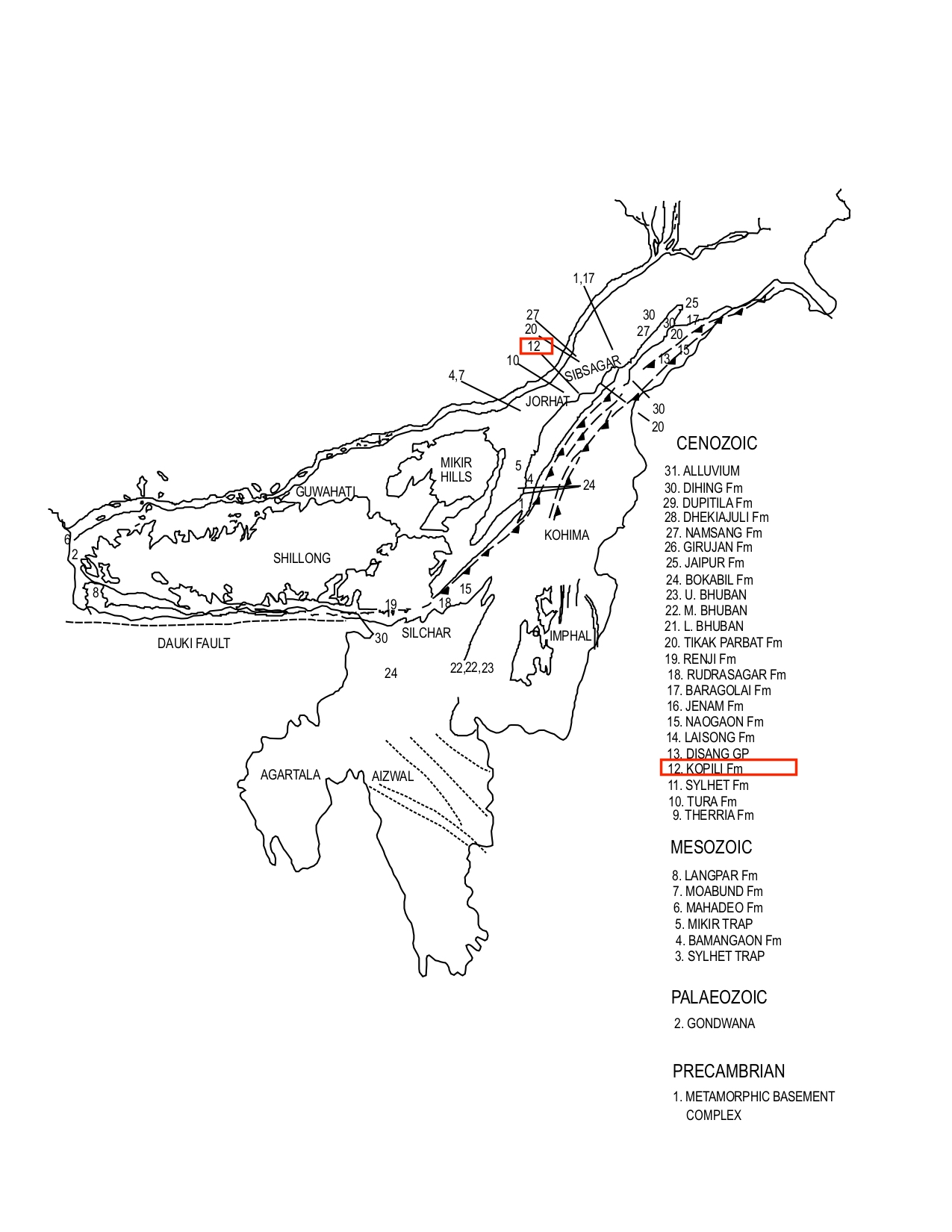
[Figure 1: Formation stratotypes of North East Basins (modified after Pandey and Dave, 1998)
Lithology and Thickness
Sandstone. Type section lithology: In the type section the formation is made of ferruginous sandstones at the base followed by carbonaceous sandstones and grey shales overlain by sandy fossiliferous mudstones. Higher up there are alternating grey shales and sandstones; above these comes a shaly group with subordinate thin bedded carbonaceous sandstones, followed by a thick hard sandstone, rather fine grained, with shell fragments. The upper part consists of shales, thin fossiliferous sandstones and sandstones. (Evans 1932). Reference section lithology: In the well Charali 1, the lower part consists of shales with thin intercalcations of fossiliferous limestones and sandstones, followed by shale (Charali Member). In the well Amguri 2, this sequence is overlain by a sequence with a sand at the base followed by a shale dominated sequence with intercalations of thin sandstones. (Amguri Member, Deshpande et al., 1993).
Relationships and Distribution
Lower contact
Conformably overlies Sylhet Fm with gradational contact.
Upper contact
Conformably overlain by the Laisong Fm of the Barail Gr. (SE Bangladesh)
Regional extent
Garo Hills, Khasi & Jaintia Hills, Mikir Hills, Dhansiri Valley, Upper Assam Shelf, Naga Schuppen Belt, Nagaland, SE and NW Bangladesh: Kopili Formation is exposed as narrow linear outcrops in the Garo, Khasi and Jaintia Hills. In the Kopili Valley and along the fringes of Mikir Hills these rocks have a wider outcrops due to gentler dips. It occurs extensively in the subsurface of Dhansiri Valley and Upper Assam and continues into the subthrust of the Schuppen Belt. In the Garo Hills, this formation is represented by thick grey to dark grey, splintery shales near the base. At places these shales are observed to grade upward into siltstones. The intercalated sandstones are usually brownish yellow, buff or grey in color, fine-grained, moderately sorted, massive and friable.
In the southern foothills of Shillong plateau in Khasi and Jainitia Hills the Kopili Formation is represented by shale with intercalated sandstone. The shales are brown to grey in color sometimes iron stained, hard and splintery. In the lower part, thick yellow grey iron stained shale with marl streaks is present. The intercalated sandstones are brown, fine grained, moderately sorted, often hard and massive or flaggy.
In the Mikir Hills the lower part of Kopili Formation is characterized by grey, dark brown, chocolate colored carbonaceous shales with thin coal streaks. The presence of thin cream to buff fossiliferous limestone in the lower part is common. The associated sandstones occurring at the higher stratigraphic level are generally cream, light grey or reddish brown in color fine to medium grained, and well sorted.
In the subsurface of Upper Assam and Dhansiri Valley, the shales are grey to dark grey, brownish grey or reddish brown, hard, compact and splintery. Thin limestones present are cream to buff colored, argillaceous and fossiliferous. The sandstone are light grey, brownish grey, fine to very fine grained, fairly well sorted quartzose in character. In the Dhansiri Valley subsurface,the proportion of sandstone in the intercalations is more but the limestone streaks are also present throughout.
In Bangladesh, it is exposed only at the bank of the Daug river in the Sylhet district where shale is dominant. In the Western Foreland Shelf area of NW Bangladesh it has been encountered as subcrops at a depths of 88 m at Gaibandha and 40 m in Singra.
GeoJSON
Fossils
The Kopili Formation yields a rich and diverse microfauna in the lower part, while towards the top the fauna is made of arenaceous foraminifera, with rare occurrence of calcareous benthics. Foraminifera fossils include Nummulites fabianii, N. beaumonti, N. pengaronensis, Discocyclina sp., Hantkenina alabamensis, G. (T). cerroazulensis.
Age
Depositional setting
The present depositional model for Kopili Formation in NE Basins is a barrier bar - tidal inlet - tidal bar - tidal flat - lagoonal – bay-head delta deposited in an inner shelf to coastal-transitional setting. The environmental mosaics, like barrier bars, tidal inlet, tidal bar, tidal flat, lagoon, are the typical components of an estuary-embayment setting. A previous worker (Naik et al., 2001) has also expressed the same view in this regard. In this setting, sediments are received by tide, wave and fluvial processes. Elongate, shore-parallel sand bars separate estuaries from open sea at the mouths of the rivers that have low-sediment loads. In Bangladesh, "The Kopili Formation was deposited in a brackish to marine condition in a shallow marine to transitional environment. The water was hyposaline to saline and the temperature varied between 10°C and 30°C." (Banglapedia, 2015).
Additional Information
Sequence Stratigraphy - North Assam Shelf:
Kopili Formation (middle to late Eocene) of North Assam Shelf could be further subdivided into three higher order sequences; viz., Sequence I, II and III, primarily based on logs and available biostratigraphic and paleobathymetric data as the seismic imaging is found to be very poor within the Kopili section. Sequence boundaries and maximum flooding surfaces have been determined from the biostratigraphy and subsequently integrated with the well logs and the paleobathymetry data. However, the identified sequences are not distinguishable in seismic sections. The identified sequences have been correlated regionally through six regional log correlations profiles. Two types of system tracts (viz., TST (Transgressive System Tract) and HST (High stand System Tract)) are found to be present in each sequence.
System tract analysis has brought out facies distribution pattern and barrier bar - lagoon - tidal inlet - tidal bar - bay head delta depositional model has been envisaged for Kopili Formation in the entire North Assam Shelf. This model will certainly aid in proper planning for exploration of Kopili Formation in North Assam Shelf.
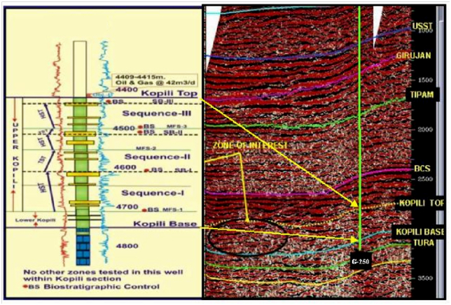
The type log and sequence stratigraphic analysis in well #E, depicting sequence boundaries, maximum flooding surfaces, and system tracts with the biostratigraphy, are shown in Figure 8. Sequences identified are summarized below.
Sequence I
It is the lowermost sequence identified within Kopili Formation. As the seismic imaging is very poor (Figure 8), in order to utilize sequence stratigraphy, the top of this sequence has been determined by intergrating biostratigraphic data with the logs. Thickness of this sequence is almost uniform. Maximum Flooding Surface (MFS) divides Sequence I into two system tracts (Trangressive System Tract (TST) and Highstand System Tract (HST). TST is primarily a shaly facies, whereas HST consists of sandy facies. By integrating logs with available biostratigraphy, cores, paleobathymetric data, and various seismic attribute maps, HST of sequence I has been mapped, showing the sand distribution pattern as well as paleoenvironmental setting of the study area for Sequence I. It is observed that sand thickness ranges from 8m (#M) to 42m (#A) within this sequence. In general sand thickness is found to increase towards east-southeast.
However, the reflection event close to Sequence I (i.e., Kopili base) is fairly correlatable in the entire area, except in some part of southeastern area, where it is patchy and diminished. The event mapped is quite conformable to the reflections corresponding to Sylhet top. The reflection time of this event ranges from 3300 to 3600 m/sec. Most of the structures are aligned along the major NE-SW fault trends and bounded by significant lows in the area. The structural picture at this level is more or less conformable to the above-mentioned level; i.e., Sequence I.
Sequence II
Sedimentary thickness of this, the middle sequence is less than that of the other two sequences. Thickness is more or less uniform. Two types of system tracts (HST and TST) are present within this sequence. HST of this sequence has been mapped and the analysis of the map is presented below:
Sand thickness ranges from 10m in #L to 33m in #A. In Amguri area thickness varies from 22-33m and from 14-27m in Charali-Demulgaon-Kuargaon area. In Lakwa-Moran-Sonari area thickness of sand ranges between 14-20m, whereas in Rudrasagar-North Rudrasagar-Rajmai area, sand thickness is between 10-18m. In Panidihing, sand thickness is in the range of 10-26m. Again in Dikhowmukh-Disangmukh area comparatively greater thickness of sand (22-29m) is observed. Sands are found to be distributed as elongate, discrete bodies particularly in Amguri-Geleki area, Charali-Demulgaon-Kuargaon area, and Lakwa-Moran-Sonari area along a linear trend. These elongate bodies strike NE-SW, the direction which is also parallel to the strike of the basin. Based on log motif, dip-meter data, and available sedimentological data, those bodies are interpreted as barrier bars that thicken towards SE. Sand geometry is indicative of bay-head deltaic setting environment.
Seismic Response Close to Sequence II Top
As the seismic reflection event corresponding to the top of Sequence II boundary is beyond seismic resolution, reflector corresponding to lower Kopili top, which is fairly close to Sequence II boundary, has been mapped. The reflection event of this horizon is found as a moderate to high amplitude event. The sand-rich package corresponds to a high impedance contrast, except in some areas towards the east and southeastern parts of the study area, where reflection below Barail is difficult to decipher. The reflection time of this event ranges from 2800 to 3200 m/sec. The structural trend is the same as that of other sequences. East-west fault trends, clearly visible in the 3-D view of the sequence structural map, perhaps developed during the latter phase of the tectonicevents.
Sequence III
This is the uppermost sequence of three identified sequences. The thickness of it is greater than that of the other two sequences. Gradually the thickness increases towards the southeast of the study area. Two types of system tracts (HST and TST) are present within this sequence. A map has been prepared for the HST to show the distribution pattern of sands within this sequence. Based on the sand distribution pattern, it is interpreted that in Geleki, Amguri, Charali, Lakwa, Moran and Sonari areas sands have been deposited as offshore bars. Towards the southwest and northwest, the depositional environment graded to lagoon. Farther towards the west the depositional setting changed to a bay head delta.
Seismic Response Close to Sequence III Top
The reflector ranges from 2600 m/sec in Disangmukh area to 5100 m/sec in Sonari–Nazira low area. It is discontinuous and patchy in the whole area. TWT relief (structure) map with 3-D view has been prepared, after correlation of this event.
[Figure 2: Type log, along with seismic response, showing sequence stratigraphic analysis in well G#250 depicting identified sequence boundary, maximum flooding surfaces, and system tracts (after Moulik Roy S.K. et al., 2009)]

